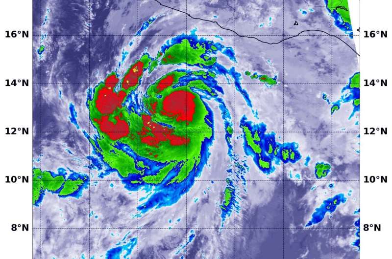
NASA infrared data shows Genevieve strengthening into a hurricane

NASA's Terra satellite used infrared light to identify strongest storms and coldest cloud top temperatures and found them surrounding a developing eyewall around Genevieve as it was strengthening into a hurricane.
Genevieve formed on Sunday by 11 a.m. EDT (1500 UTC) as Tropical Depression 12E. Six hours later, by 5 p.m. EDT, it had strengthened into a tropical storm and was renamed Tropical Storm Genevieve. The storm continued to intensify rapidly and by 11 a.m. EDT on Monday, Aug. 17, it strengthened to a hurricane.
Infrared Data Reveals Powerful Storms
On Aug. 17 at 1:15 a.m. EDT (0515 UTC), the Moderate Resolution Imaging Spectroradiometer or MODIS instrument aboard NASA's Terra satellite gathered temperature information about Genevieve's cloud tops. Infrared data provides temperature information, and the strongest thunderstorms that reach high into the atmosphere have the coldest cloud top temperatures.
MODIS found the most powerful thunderstorms were in the eyewall, where temperatures were as cold as or colder than minus 70 degrees Fahrenheit (minus 56.6 Celsius) around the center of circulation and in thick, fragmented bands south and west of the center. Cloud top temperatures that cold indicate strong storms with the potential to generate heavy rainfall.
Genevieve's Status
At 11 a.m. EDT (1500 UTC) on Aug. 17, NOAA's National Hurricane Center reported the center of Hurricane Genevieve was located near latitude 14.3 degrees north and longitude 103.0 degrees west. The storm was about 250 miles (405 km) south-southwest of Zihuatanejo, Mexico.
Genevieve is moving toward the west-northwest near 18 mph (30 kph), and this motion is expected to continue through tonight. Maximum sustained winds are near 75 mph (120 kph) with higher gusts.
Forecast Track
NHC forecasters said, "A turn to the northwest and a decrease in forward speed is forecast to occur on Tuesday and continue through at least early Thursday. Rapid strengthening if forecast to continue over the next day or so, and Genevieve is expected to become a major hurricane on Tuesday. A weakening trend should begin on Wednesday. On the forecast track, the center of Genevieve is expected to move parallel to but well offshore the coast of southwestern Mexico during the next couple of days."
Genevieve Causing Dangerous Ocean Swells Near Mexico
Large swells produced by Genevieve will begin affecting portions of the southern coast of Mexico today and will spread northward along the southwestern and west-central coast of Mexico to the Baja California peninsula through Wednesday. These swells are likely to cause life-threatening surf and rip current conditions.
NASA Researches Tropical Cyclones
Tropical cyclones/hurricanes are the most powerful weather events on Earth. NASA's expertise in space and scientific exploration contributes to essential services provided to the American people by other federal agencies, such as hurricane weather forecasting.
Provided by NASA's Goddard Space Flight Center


