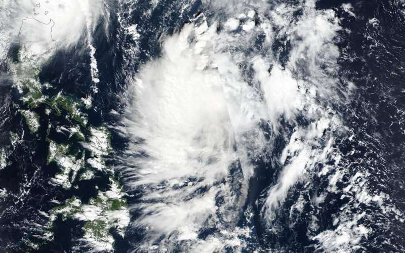
NASA tracks Typhoon Kalmaegi affecting Northern Philippines

NASA's Terra satellite captured an image of Typhoon Kalmaegi as it moved into the Luzon Strait and continued to affect the northern Philippines.
On Nov. 19, Kalmaegi's western edge was in the Luzon Strait, while its southern quadrant was over the northern Philippines. The Luzon Strait is located between Taiwan and Luzon, Philippines. The strait connects the Philippine Sea to the South China Sea in the northwestern Pacific Ocean.
Kalmaegi is known locally in the Philippines as Tropical Cyclone Ramon, and there are many warning signals in effect for the northern Philippines.
Signal #3 is in effect for the Luzon provinces of Northern portion of Cagayan (Santa Praxedes), Claveria, Sanchez Mira, Pamplona, Abulug, Ballesteros, Aparri, Calayan, Camalaniugan, Buguey, Santa Teresita, Gonzaga and Santa Ana. Signal #2 is in effect for the Luzon provinces of Batanes, Apayao, Kalinga, Abra, Ilocos Norte & Sur and the rest of Cagayan. Signal #1 is in effect for the Luzon provinces of Northern portion of Isabela (Sta. Maria), San Pablo, Maconacon, Cabagan, Sto. Tomas, Quezon, Delfin Albano, Tumauini, Divilacan, Quirino, Roxas, Mallig, San Manuel, Burgos, Gamu and Ilagan City, Mountain Province, Benguet, Ifugao, La Union, and Pangasinan.
On Nov. 19, the Moderate Imaging Spectroradiometer or MODIS instrument that flies aboard NASA's Terra satellite provided a visible image of Kalmaegi. The MODIS image showed the hint of an oblong eye covered by high clouds. Forecasters at the Joint Typhoon Warning Center noted that eye had collapsed due to deteriorating environmental conditions.
At 10 a.m. EST (1500 UTC), Typhoon Kalmaegi was located near 19.4 degrees north latitude and 122.5 degrees east longitude. That is about 301 nautical miles north-northeast of Manila, Philippines. The storm is barely moving, however. It is moving to the west at 1 knot (1 mph/1.8 kph). Maximum sustained winds were near 75 knots (86 mph/139 kph).
Kalmaegi is turning toward a southwesterly course, which will take it across northwestern Luzon (northern Philippines). The storm will start to weaken, later rapidly, as it moves into the South China Sea.
NASA's Terra satellite is one in a fleet of NASA satellites that provide data for hurricane research.Typhoons and hurricanes are the most powerful weather event on Earth. NASA's expertise in space and scientific exploration contributes to essential services provided to the American people by other federal agencies, such as hurricane weather forecasting.
Provided by NASA's Goddard Space Flight Center


